Mostrar mensagens com a etiqueta Resultados da Conceção. Mostrar todas as mensagens

sexta-feira, 14 de junho de 2013

Vídeo Final

E aqui está o nosso vídeo final: http://www.youtube.com/watch?v=vFD0u6eyPhA
 
Mais uma vez, pedimos desculpa pela péssima qualidade de áudio.
 
 
 Apesar do Ciclo 4 de Pilotagens do iTEC terminar hoje, pedimos que deixem os vossos comentários/sugestões acerca do nosso filme, aqui no blog, no YouTube, ou no grupo do Facebook iTEC Students Collaborate.

segunda-feira, 10 de dezembro de 2012

Percurso final


Ver Margens do Rio Mira em Santa Clara num mapa maior


 O tão esperado percurso georreferenciado está aqui mesmo! Os frutos do nosso trabalho neste Projeto iTEC estão evidenciados, nomeadamente, neste percurso. É claro que não é tudo, mas já é uma boa parte. 
 Esperemos que sirva para vos mostrar um pouco do que há nestes lados...

Percurso *quase* final


Visualizar Margens do Rio Mira em Santa Clara em um mapa maior

segunda-feira, 3 de dezembro de 2012

Uma pequena (grande) alteração


Ver Margens do Rio Mira em Santa Clara num mapa maior


[PT] Na passada quinta feira recolhemos opiniões/sugestões de alguns convidados que participaram na nossa sessão de apresentação do protótipo (quase) final...mediante essas mesmas opiniões/sugestões melhorámos o nosso percurso pedestre, que tem uma semana para ficar completamente terminado. Já faltou muito mais!!

[ENG] Last Thursday we collected opinions/suggestions from some guests who participated in our session presentation of the prototype (almost) final ... by those opinions/suggestions we improved our footpath, which has a week to get completely finished. It already missed much!

Percurso pedestre (quase pronto!!)


Ver Margens do Rio Mira em Santa Clara num mapa maior

terça-feira, 27 de novembro de 2012

Percurso modificado (fotos)


Visualizar Margens do Rio Mira em Santa-Clara-a-Velha em um mapa maior


[PT] Durante esta tarde a nossa equipa reuniu-se, na aula de Ciências, e o resultado está aqui! Na publicação anterior tínhamos apenas postado o mapa que continha somente texto. Adicionámos agora fotos, que ilustram (esperemos que bem!) o texto também aqui apresentado.


[ING] During this afternoon our team met in the Science lesson, and the result is here! In the previous publication we had just posted the map containing only text. Now we've added photos that illustrate (hopefully good!) the text also presented here.


Melhoramentos no percurso pedestre no Google Earth


Visualizar Margens do Rio Mira em Santa-Clara-a-Velha em um mapa maior


terça-feira, 20 de novembro de 2012

O nosso percurso georreferenciado


Ver Margens do Rio Mira em Santa Clara num mapa maior


 [PT]E aqui está o tão aguardado percurso georreferenciado! Ainda não está completo...mas temos uma semana para fazê-lo. Embora não seja muito tempo, se conseguirmos cooperar uns com os outros, mesmo que não seja com elementos da equipa, tudo se tornará mais simples...

[English] And here is the much awaited georeferenced path! It isn't complete ... but we have an week to do it. Although it is not much time, if we manage cooperate with each other, even it is not with members of the team, everything will become simpler ...

sexta-feira, 16 de novembro de 2012

Pelos arredores de S. Luís...

 [PT] Na última publicação partilhámos o resultado da segunda saída de campo, na praia do Carvalhal e Azenha do Mar. Agora vamos mostrar-lhe os "frutos" da terceira e última saída de campo, no Vale Bejinha, Troviscais e Casa Branca. Esta área, tal como a da saída anterior, também pertence ao Parque Natural  do Sudoeste Alentejano e  Costa Vicentina.

[ENG] In the last publication we shared the results of the second field trip, the Carvalhal beach and "Azenha do Mar". Now, we are going to show you the "fruits" of the third and final field trip, in the Bejinha Valley, "Troviscais" and White House. This area, like the previous output, also belongs to the Natural Park of Southwest Alentejo and Vicentin Coast.

[PT] Ponto 1 ---> Fonte

[PT] Fonte
[ENG] Source
 Em 1936, o Plano Rodoviário Nacional construiu uma rede de estradas por todo o país. Esta estrada (em S. Luís) era muito frequentada para quem se dirigia a Lisboa.
 Até então, a circulação era feita por via marítima.


[PT] Ponte - local de albergaria de uma espécie rara de morcegos
[ENG] Bridge - lodge local of a rare species of bats

 Na imagem ao lado pode-se observar um local
que, aparentemente, é bastante normal...mas não é bem assim: por baixo desta ponte existe uma espécie rara de morcegos.


[ENG] Point 1 ---> Source

 In 1936, the National Road Plan has built a network of roads across the country. This road (in St. Louis) was very popular for those which headed to Lisbon.
 Until then, the movement was made ​​by sea.

 In the next image we can see a place that apparently is quite normal ... but it's not like that: underneath this bridge exist a rare species of bats.


[PT] Ponto 2 ---> "Matagal"

 A flora e fauna aqui existentes são típicas do bosque mediterrânico. Merecem destaque a Azinheira, o Medronheiro, o Amieiro, o Carvalho, o Sobreiro (grande parte já lhe foi retirada a cortiça)... Para além da avifauna audível, conseguimos avistar uma garça real. E sabemos da existência de javalis nesta mesma área.
 Este local é uma espécie de "testemunho do passado". Por isso mesmo, é quase que considerado Museu Arqueológico.
 Aqui, tal como em Sta Clara, existem árvores com líquenes bioindicadores, ou seja, indicam que esta é uma zona não poluída. Também existem Juníperos, o que indica que há muito tempo que não existem incêndios nesta zona. Falando ainda em incêndios, sabemos que aqui o fogo não avança tão rapidamente, devido à diversidade de flora. Não encontramos uma espécie que seja mais predominante que todas as outras neste local, mas sim um conjunto de variadas espécies, em quantidades similares, que não se encontram concentradas. 

[PT] Pegada de javali e pormenor de manta morta
[ENG]  Boar footprint  and detail of dead plaid
Na imagem ao lado pode observar-se o pormenor de manta morta existente neste mato. A mata morta forma-se a partir da acumulação de folhas que caem de algumas árvores. Esta manta retém as águas das chuvas. Também se pode ver uma pegada, possivelmente de um javali.


[PT] Árvore de folha caduca
[ENG] Deciduous tree

[PT] Sobreiro
[ENG] Corktree

[PT] Líquenes (bioindicadores)
[ENG] Lichens (biomarkers)

[PT] Cogumelo
[ENG] Mushroom


[ENG] Point 2 ---> "Scrub"

The flora and fauna existing here are typical of Mediterranean forest. Noteworthy to Holm, the Arbutus, the Alder, the oak, the Corktree (it was already largely removed the cork) ... In addition to the avifauna audible, we spot a heron. And we know the existence of wild boars in this same area.
  This site is a sort of "witness of the past." Therefore, it is almost considered Archaeological Museum.

Here, as in Sta Clara, bioindicators are no trees with lichens, ie indicate that this is a not polluted area. There are also juniper, indicating that long time that there are not fire in this area. Speaking also on fire, here we know that the fire does not go as fast, due to the diversity of flora. We could not find a kind that is more prevalent than all other at this location, but a number of different species, in similar quantities, that are not concentrated.

In the next image can be seen the detail of this existing blanket dead bush. The bush dead formed from the accumulation of falling leaves of some trees. This blanket traps the rainwater. You can also see a footprint, possibly a boar.


[PT] Ponto 3---> Antigo armazém de produção de arroz (junto ao Rio Mira)

 Neste local existe um armazém que fechou à cerca de 20 anos, e que até então fazia produção de arroz. Este armazém praticava uma ação que colocava em causa a saúde do rio: o trigo e a cortiça eram escoados para o rio. Esta fábrica pertencia à EPAC - Empresa Pública de Abastecimento de Cereais - mas quando fechou foi entregue ao Estado, que por sua vez passou o seu domínio à ISN, atual ICNF. Fizeram-se obras nesta fábrica, e é hoje em dia utilizada para fazer festas da Aldeia, e também para guardar instrumentos agrícolas.
 Falando mais propriamente do rio Mira, é importante salientar que este rio tem uma característica muito própria: ele "corre" de montante para jusante, mas, passadas algumas horas, a corrente passa a ter o sentido inverso. Isto deve-se à influência exercida pelo mar. Sabemos da existência de lontras, lagostins, ostras, amêijoas, camarões... Este rio é uma importante "maternidade" de peixes e anfíbios.
 Ao observarmos as margens direita e esquerda do rio, apercebemo-nos de uma diferença: na margem esquerda existem arbustos de algum porte, o que não se verifica na margem direita.
 Junto ao Rio a flora existente passa muito pela Tabua, Junco e ainda alguns arbustos, como já referimos.  Nos subúrbios deste cais predomina o montado, o Medronheiro, os Eucaliptos, as Urzes, Estevas...

[ENG] Point 3 ---> Old Warehouse of rice production (next to the Mira River)

 In this place there is a store that closed at about 20 years, and that until then had rice production. This warehouse practiced an action that put into question the health of the river, wheat and cork were disposed into the river. This mill belonged to EPAC - Public Company Supply Cereals - but when it was delivered to the closed state, which in turn passed to your domain ISN, current ICNF. Works were made in this factory, and is now used to make the Village feasts, and also for storing agricultural implements.
 Speaking more specifically the River Mira, it is important to note that this river has a very unique feature: it "runs" from upstream to downstream, but after a few hours, the chain is replaced by the reverse. This is due to the influence of the sea. We know of the existence of otters, crayfish, oysters, clams, shrimp ... This river is an important "motherhood" of fish and amphibians.
 By observing the left and right banks of the river, we see a difference: on the left there are bushes of some size, which does not appear in the right margin.
 Along the River we can see Tabua, Junco and even some shrubs, as we've already noted. In the suburbs of this pier predominates thw Mounted, Arbutus, Eucalyptus, Heathers, Estevas ...


[PT] Vegetação do rio Mira
[ENG] Vegetation of the Mira River 

[PT] Margens esquerda e direita do Rio Mira
[ENG]  Left and right banks of the Mira River 

[PT] Margem do Rio Mira
[ENG] Mira's Riverbank 

[PT] Rio Mira
[ENG] Mira River 

[PT] Armazém
[ENG] Warehouse

[PT] Montado
[ENG] Mounted

[PT] Ponto 4---> Sapal

 Este Sapal foi abandonado à cerca de 20 anos, altura em que o armazém fechou, e era aqui que se produzia o arroz, que tinha como base um recurso de água ali existente.
 A argila aqui secou.
 Aqui predominam os Sobreiros, Medronheiros, Salva, Junco, Tabua, Esteva...


[ENG] Point 4 ---> Marshland

  This Marshland was abandoned at about 20 years, when the store closed, and it was here that the rice was produced, which was based on a resource of water therein.
  The dried clay here.
  Here are predominant Corktree, arbutus, Salva, Junco, Tabua, Esteva ...


[PT] Sapal
[ENG] Marshland

[PT] Sapal
[ENG] Marshland 

[PT] Sapal
[ENG] Marshland 


[PT] Argila (seca)
[ENG] Clay (dry)

[PT] Vegetação típica do Sapal
[ENG] Marshland typical vegetation 
[PT] Ponto 5---> Vale Bejinha

 Neste ponto avistámos uma herdade, unidade de produção da Vilé Romana. Antigamente viviam aqui trabalhadores, que viviam da produção autónoma. O edifício central era uma Capela, onde se praticava, por exemplo, a "Bênção do Galo".
 Toda esta extensa planície é típica do Alentejo, onde se destacam os Sobreiros.


[ENG] Point 5 ---> Bejinha Valley

  At this point we saw a farm, production unit Vile Roman. Workers once lived here, who lived in independent production. The central building was a chapel, where he practiced, for example, the "Blessing of the Rooster."
  All this vast plain is typical of the Alentejo, where we highlight the oaks.


[PT] Sobreiros
[ENG] Corktree

[PT] Planície, típica do Alentejo
[ENG] Plain, typical of the Alentejo


[PT] Herdade da Vilé Romana
[ENG] "Vilé Romana" homestead

[PT] Herdade
[ENG] Homestead


[PT] Ponto 6---> Moinho da Laje

 Nesta última saída de campo visitámos o Moinho da Laje, onde pudemos desfrutar de uma paisagem deslumbrante. Infelizmente, não chegamos em boas horas, pelo que não pudemos ver o interior do Moinho.


[ENG] Point 6 ---> Mill Slab

  In this last field trip we visited the mill slab, where we could enjoy a breathtaking view. Unfortunately we got good hours, so we could not see inside the mill.


[PT] Vista através do Moinho
[ENG] Looking through the Mill

[PT] Vista do Moinho da Laje
[ENG] View from Mill Slab

[PT] Moinho da Laje
[ENG] Mill Slab

[PT] Paisagem vista no Moinho da Laje
[ENG] Landscape view in Mill Slab

Praia do Carvalhal & Azenha do Mar

[PT] Como já referimos em publicações anteriores, realizaram-se na semana passada as duas últimas saídas de campo: uma na praia do Carvalhal e outra na zona de S. Luís, ambas localizadas em áreas pertencentes ao Parque Natural do Sudoeste Alentejano e Costa Vicentina. 

 Relativamente à segunda saída de campo - praia do Carvalhal e Azenha do Mar - é importante salientar que esta zona, graças ao seu impecável estado de conservação, pertence ao Parque Natural do Sudoeste Alentejano e Costa Vicentina. É também uma zona de interface entre o mar e a terra, logo vai apresentar fauna e flora diferentes da 1ª saída, em que todo o ecossistema era típico de uma zona ribeirinha.
 Na praia do Carvalhal, as cegonhas (Cicónia Cicónia) nidificam nas falésias, ou em rochas isoladas do mar, o que é um caso raro no Mundo.
 Diz-se que há cerca de 65 milhões de anos atrás (época de extinção dos dinossauros) as enseadas eram o esconderijo de tesouros que alguns piratas escondiam. Como esta zona não era povoada, os piratas até tinham motivos para considerarem este um local ideal para esconderijo. Neste mesmo local, podemos observar estratos sedimentares horizontais inclinados.
 A nível marinho, esta zona é rica em fauna do Norte de África, do Mediterrâneo e do Oceano Atlântico. Aqui existem baleias, tartarugas marinhas e cágados.
 Na Azenha do Mar pudemos assistir à chegada de barcos de pesca, e por sua vez os resultados dessa mesma pescaria. Entre muitos outros, destacam-se as Fanecas, Raias, Espargos, Cavalas, Abróteas, Robalos, Safios, Peixe-Agulha...

[PT] Rocha calcária (zona destacada)
[ING] Limestone (highlighted area)
 A parte que está destacada na imagem ao lado é o resultado da brusca evaporação dos sais minerais, que formaram esta rocha calcária, situada bem no topo desta arriba. Em tempos, extraíam-se porções desta rocha para a produção de rodas de moinhos.

[ING] As mentioned in previous publications, were held last week the last two field trips: one in Carvalhal beach and another in the area of S. Louis, both located in areas belonging to the Natural Park of Southwest Alentejo and Costa Vicentina.


For the second field trip - Carvalhal beach and Azenha Sea - is important to note that this area, thanks to its flawless condition, belongs to the Natural Park of Southwest Alentejo and Costa Vicentina. It is also an area of ​​interface between sea and land, will soon present fauna and flora of different 1st exit, where the entire ecosystem was typical of a waterfront.
  In Carvalhal beach, storks (Ciconia ciconia) nest on cliffs, rocks or isolated from the sea, which is a rare case in the world.
 It is said that there are about 65 million years ago (the time of extinction of the dinosaurs) inlets were the hideout of pirates hid some treasures. As this area was not populated until the pirates had reason to consider this an ideal place to hide. In this same area, we can see horizontal sedimentary strata inclined.
  The sea level, this area is rich in fauna of North Africa, the Mediterranean and the Atlantic Ocean. Here there are whales, turtles and tortoises.
  In Azenha Sea could watch the arrival of fishing boats, and in turn the results of that fishery. Among many others, there are the pout, Rays, Asparagus, Mackerel Forkbeards, Bass, challenges, Needle Fish ...

The part that is highlighted in the picture is the result of the sudden evaporation of minerals, which formed this limestone that sits on top of this cliff. At times, this portion is extracted for the production of rock wheels mills.


[PT] Praia do Carvalhal
[ING] Carvalhal Beach


[PT] Azenha do Mar
[ING] (Azenha Sea)


[PT] Azenha do Mar
[ING] (Azenha Sea)
 [PT] No caminho de regresso a casa/escola, pudemos observar a presença humana, através da agricultura intensiva. Nas muitas estufas que vimos, controlam-se os fatores abióticos (humidade, temperatura...) artificialmente, o que não é positivo.

[ING]On the way back home / school, we could observe the human presence, through intensive agriculture. In many greenhouses we saw, to control the abiotic factors (humidity, temperature ...) artificially, which is not positive.

segunda-feira, 5 de novembro de 2012

Mais um pouco do que temos para partilhar

 [PT] Para aquelas pessoas que viram a publicação em que postámos fotos e lhes "soube a pouco", aqui ficam mais algumas:

 [English] For those people who have seen the publication where we post pictures and it wasn't enougth, here are a few more:

[PT] Vista do açude
[English] View from the dam

[PT] Açude
[English] Dam

[PT] Amieiro
[English] Alder


[PT] Ponte D. Maria
[English] Mary's bridge

[PT] Ponte D. Maria
[English] Mary's bridge


[PT] Acácia (invasora)
[English] Acacia (invador)

[PT] Freixo
[English] Ash
[PT] Lagar
[English] Wine press

[PT] Vista do Rio Mira (através do Lagar)
[English] View of the Mira River (through the Wine press)


terça-feira, 30 de outubro de 2012

...e eis o resultado final (da 1ª saída)!

 [PT] Como sabem, na passada quinta feira saímos para o campo. Hoje, estamos aqui a mostrar-vos o resultado final. Ora vejam lá:

 [English] As you know, last Thursday we went out to the field. Today, we are here to show you the final results. Prays see there:


[PT] Salgueiro (também conhecido por chorão)
[English] Willow tree (aka crying)

 [PT] 
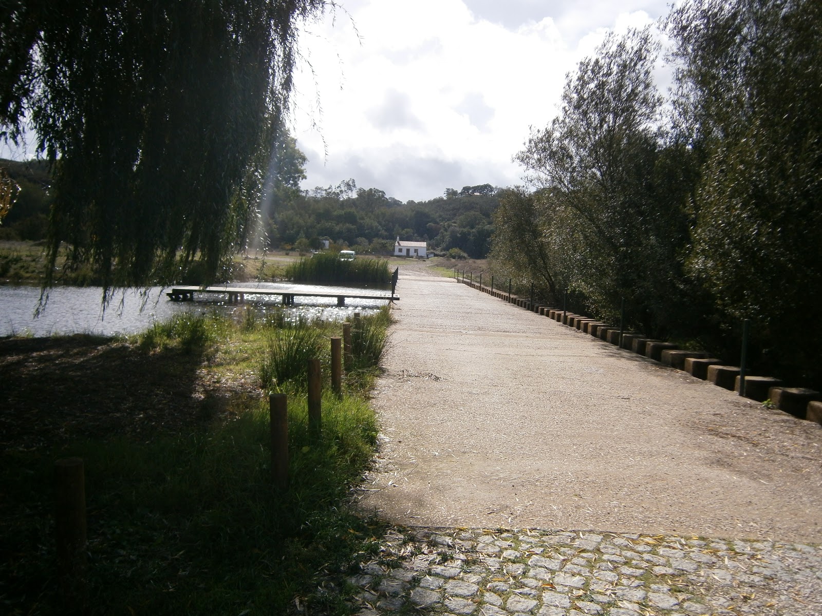
Ponto de encontro- Chorão: Neste ponto pudemos observar os imponentes salgueiros (do latim Salix). Também são aqui visíveis intervenções humanas - o açude e duas caixas coletoras de águas pluviais - que causaram alterações no rio. Com a construção do açude (em 1997), que visionava a utilização desta mesma água pela população, surgiu um problema: as águas ficaram demasiadamente poluídas. Mas é importante salientar que do lado direito do açude colocaram-se "barras" de cimento, que têm brechas, o que mantém o percurso original do rio. Mas voltando ao problema: para a sua resolução foi necessário "unir forças". Criou--se um grupo de voluntariado que entrou em contacto com a Junta de Freguesia, (que também ambicionava um rio saudável), e que por sua vez informou a ARH, que logo se propôs a ajudar na limpeza do excesso de matéria orgânica acumulada no fundo do rio.
 Em 2009 criaram-se as tais caixas coletoras de águas pluviais, que faziam ligação com o rio. Estas foram restauradas por um artista recentemente.
 Hoje em dia este espaço está mais acolhedor às pessoas que simplesmente procuram um espaço verde onde possam conviver fora do stress do dia a dia. A Câmara Municipal colocou alguns postes para "desviar" os carros que estacionavam naquela zona, e lembrou-se também de colocar (um) caixote do lixo!
  
 [English] Meeting point-whiner- aka crying:At this point we could see the towering Willow (Latin Salix).  The human interventions are also visible here - the weir and two boxes collecting rainwater - which caused changes in the river. With the construction of the dam (in 1997), which envisioned the use of that water for the population, a problem arose: the waters were too polluted. But it is important to note that the right side of the dam put up "bars" of cement, which have gaps, which keeps the original route of the river. But back to the problem: for their resolution was necessary to "join forces". A group of volunteers came into contact with the Parish Council, (who also aspired to a healthy river), and that in turn informed the ARH, who soon offered to help in cleaning the excess organic matter accumulated in the bottom of the river.
  In 2009,  were created the collecting rainwater boxes, that linked with the river. These were recently restored by an artist.
  Today this space is more welcoming to people who are simply seeking a green space where they can live out the stress of everyday life. The council put some stakes near the river to "persuade" the drivers not to park the cars in the area, and also remembered to put (one) dustbin!

[PT] Açude
[English] Dam


 [PT] Ponto 2- A jusante do açude: É aqui que se dá a descarga das águas pluviais acumuladas nas caixas coletoras. Há uma diminuição indireta, em que a água tem odor desagradável e cor acastanhada. Felizmente, não é grave em termos de saúde do rio, pois aqui a poluição não se encontra acumulada.

 [English] Point 2 - Downstream of the dam:  It is here that gives the discharge of rainwater accumulated in the collecting boxes. There is an indirect reduction, in which the water has an unpleasant odor and brownish color. Fortunately, it is not serious in terms of the health of the river, because the pollution here is not cumulative.
[PT] Local de descarga das águas acumuladas nas caixas coletoras (a jusante do rio)
[Emglish]  Discharge local of the waters accumulated in the collecting boxes (downstream of the river)
 [PT] Ponto 3- Rebaixamento: Na margem esquerda do rio fizeram um rebaixamento para, quando o nível das águas do rio subir, haver continuidade do caudal, através da técnica do by pass, em que a água passa por encaixe. O problema é que não foram feitos os cálculos suficientes para que o rebaixamento funcionasse.
 É importante ter em conta que um rio é um sistema aberto.
 Na continuação do rebaixamento encontramos lagostins jovens. Um dos nossos colegas até teve a honra de  segurar num!

 O nosso rio tem uma comporta de emergência, para o caso de a água se contaminar. Nestes lados encontramos excrementos de Lontra. Interessante, não?

 [English] Point 3 - Lowering: On the left bank of the river they  made a downgrade, for when the water level of the river rises, there is continuity of flow through the bypass technique in which water passes through fitting. The problem is that the calculations were not made sufficient for the downgrade worked.
 It is important to note that a river is an open system.
 In continuation of the drawdown we can find young crayfish. One of our colleagues even had the honor of holding one!

 Our river has a floodgate of emergency, in case the water contaminates itself. In these sides we can find Otter droppings. Interesting, no?
[PT] Rebaixamento (lado direito do junco e da tabua)
[English] Drawdown (right side of the reed and "tabua")


[PT] Continuação do rebaixamento (mais para a direita da imagem anterior)
[English] Continuation of the drawdown (further to the right of the previous image)


[PT] Lagostim (bem) jovem!
[English] Crayfish (very) young!


 [PT] Ponto 4- Caminho do rio até à ponte D. Maria: A nossa zona ribeirinha é rica em vegetação, na qual pudemos encontrar Salgueiros, Loendros, Amieiros, Acer, Freixos, e, infelizmente, Acácias invasoras. Quando temos um local fechado (como é um dos casos), em que não há camadas de sementes a cobrir o chão e as Acácias ainda não são adultas, podemos recorrer à irradicação da Acácia. Neste caso, utiliza-se uma pinça escavadora em que sai o raízame principal. Quando temos um espaço aberto sem as condições referidas, a única hipótese que não requer grandes financiamentos é a que consiste em controlar a Acácia, o que não é nada fácil, visto que cada uma pode durar mais de 50 anos!

 Também fazem parte desta vegetação as inúmeras tabuas e juncos.

 Sabemos que próximo do rio há excesso de matéria orgânica (eutrofização). Mas a melhor parte é que nesses mesmos lados não há poluição! E não existe melhor prova que os Freixos com bioindicadores (líquenes).

 [English] Point 4- Way of the river to the Mary's bridge : Our waterfront is rich in vegetation, in which we find Willows, Loendros, Alders, Acer, Ash trees, and, unfortunately, invasive Acacias. When we have a closed spot (as in this case), in which there are layers of seeds to cover the floor and Acacias are not yet mature, we can use the eradication of Acacia. In this case, it is used a gripper excavator that takes the main rooting. When we have an open space without the conditions mentioned, the only option that does not require major funding is that which consists in controlling the Acacia, which is not easy, since each one can last over 50 years!

 Also part of this vegetation are the numerous "tabuas" and reeds.

 We know that close to the river's exists excess organic matter (eutrophication). But the best part is that these same sides have no pollution! And there is no better proof of that than the presence of the ash trees and  the   bioindicators (lichens).


[PT] Loendro
[English] "Loendro"

[PT] Sementes de acácia
[English] Acacia seeds

[PT] Vestígios de Acácia
[English] Acacia vestiges
[PT] Tabuas
[English] "Tabua"

[PT] Freixo com bioindicadores (líquenes)
[English] Ash with bioindicators (lichens)

 [PT] Ponto 5- Ponte D. Maria: Quando aqui chegámos deslumbrá-mo-nos com uma paisagem sobrenatural! A Ponte é considerada Património Municipal, tal como as poucas noras que também existem nestes arredores. O pior é que existem problemas que se vão sobrepor à paisagem esplêndida... comecemos pelas "supostas" escadas: não têm fácil acesso, e são feitas com chapas, o quem nem estética tem; nas envolventes achamos que o material utilizado (vigas de aço) não é minimamente seguro, pois escorrega muito. Ainda por cima a maior parte da população que habita nos arredores já se encontra numa fase avançada, o que torna o caso ainda pior; por último, não gostámos da cimentação das pedras em saibro e reboco. 

 [English] Point 5- Mary's bridge: When we got here we were amazed with such a supernatural landscape! The Bridge is considered Heritage Hall, as the fewer noras that also exist in these surroundings. What's worse is that there are problems that will override the splendid landscape ... starting by "alleged" stairs: they have no easy access, and are made with metal plates, tasteless; in  the surroundings we think the material used (steel beams) is not minimally safe, because slips too. Most of all the population living around this place is already at an advanced stage, which makes the case even worse, and finally, we didn't like the cementing stones in clay and plaster.

[PT] "Paraíso dos nenúfares"
[English] "Paradise of waterlilies"

[PT] Talha-mares (material que suporta a ponte)
[English] "Talha-mares" (material that supports the bridge)

[PT] Ponte D. Maria
[English] Mary's bridge
 [PT] Ponto 6- Lagar de azeite: É considerado Património Arqueológico industrial. Antigamente era praticada aqui a produção de azeite, que por questões monetárias (segundo o que se sabe) fechou. O grande problema deste Lagar é que, depois de espremidas as azeitonas, "lançava" essas águas e outras já utilizadas ao rio, o que era encarado como poluição, mas que no fim até nem era grave, porque ainda nesse tempo não existia a barragem, e muito menos o açude, portanto a água tinha a possibilidade de se renovar.
 Hoje em dia o equipamento encontra-se quase intacto, portanto poderá ainda surgir como museu vivo, ou até por demonstração da produção do azeite. Outra ideia é a de criar uma zona de lazer onde se possa apoiar ideias que venham a melhorar o rio. 

 [English] Point 6- Lagar oil: It's an industrial Archaeological Heritage. Formerly practiced here the production of oil, which in monetary matters (according to what is known) closed. The big problem is that this Lagar after squashed olives, "threw" those waters and others used to the river, which was regarded as pollution, but in the end was not even serious, because even at that time there was no lake, much less the dam, so the water was able to renew itself.
 Nowadays the equipment is almost intact, so there may yet emerge as a living museum, or even a demonstration of the production of oil. Another idea is to create a recreational area where we can support ideas that will improve the river.
[PT] Lagar de azeite
[English] Lagar oil


[PT] E a nossa saída termina com uma foto de grupo!
[English] And our output field ends with a group photo!


[PT] Curiosidades:


- A Barragem de Sta Clara encontra-se a 3Km do nosso ponto de partida (Chorão);
- A Barragem foi construída a pensar na regalia de toda a população e também no aproveitamento hidroagrícola, que consiste na rega de campos no litoral de Odemira, e o "business for Biodiversity" é a 'empresa mãe', que tira grande parte dos lucros;
- As propriedades envolventes ao rio pertencem ao estado, mas são simultaneamente privadas...por enquanto, a população pode aceder ao rio! Esperemos que não mude! É nestes casos que os voluntários têm um papel determinante...

[English] Curiosities:


- Sta Clara's lake is 3km from our point of departure (whiner);
- The lake was built regarding the entire population and also with the purpose of hydroagricultural use, which consists of irrigating fields in Odemira coast, and "business for Biodiversity" is the 'parent' who takes most of the profits;
- The properties surrounding the river belong to the state, but are simultaneously private ... but at the moment the population can access the river! We hope that does not change! This is where volunteers have a key role...